I have wanted to do hike the Subway in Zion National Park for quite some time and finally got the chance. Jim Sorenson, my dentist and fellow geocacher, invited me to go with a group he organized which consisted of himself, his wife Valynn, a 16 year old exchange student from Italy named Ellie, a cousin, the cousin's friend and the friends father. If I had done this right after the hike I might have been able to remember the names, but over a month later, no way.

We met at the Kolob visitor's center on September 3 where we picked up permits, then headed on down the road to Virgin where we took the Kolob Terrace road. We dropped one vehicle about eight miles up the road at the Left Fork Trailhead where we would end the hike, then continued on about another eight miles to Wildcat Trailhead to begin the hike.

There isn't a maintained trail, so you just have to kind of head in a southeasterly direction and follow the rock cairns. You go over a ridge, then drop down over a lot of white and red sandstone, continuing in a southerly direction until you reach the canyon.
 Here you drop down about 150 feet into a slot canyon. At this time of year there was only a few pools of stagnant water at this point, but as you continue down the canyon water springs up and comes in from side canyons and becomes a pretty good stream. Before long you come to pools of water where you have to swim. It is good to have a dry bag for protecting valuables. A wetsuit might be nice if the water is really cold; you will be soaked for over an hour.
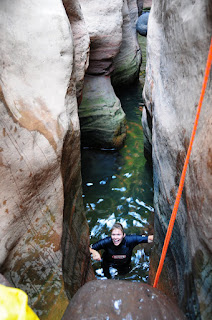
There are at least four places where you have to use a rope to get down over the rocks, and at at least one of them you end up in waist deep water .


At one of the deep holes I about drowned my $2000 camera. It didn't look that deep, and wasn't that far across so I just held my camera over my head. When I got into the hole I discovered that I couldn't touch bottom, so I was treading water with one hand and holding the camera with the other. When I got across Ellie was blocking my way out. the rocks were too slick to get a foothold and I was having a real hard time staying above water. Finally I decided I had to grab onto Ellie or get my camera wet. When she could move ahead she helped me out and we saved the camera and most of my dignity.

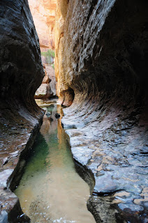
The photos below show how the canyon got it's name. The water has eroded the canyon walls in a circular fashion to make it look like a tunnel.


Below is one of the places where you need a rope to get down. At least most people do. One of the guys slid down the rock as far as he could, then jumped into the pool below. Not a recommended method as it would be quite a job to get someone out of there with a broken leg.


After this point the canyon widens out and there are no more rappels or forced swims. there were thunderheads gathering above us and we were glad we made it this far before the weather got any worse. On down the canyon a couple of miles is the trail out. You hike up the steep rocky slope shown below and come out of the canyon near the Left Fork Trailhead where we left a vehicle.

What a beautiful place to be, but there is no way I could ever do that. Don't you get claustrophobia (sp)? You have quite a few fun things to tell about.....can't wait to read about all of them.
ReplyDeleteThat looks fun. Miss you guys.
ReplyDeleteWow, that looks fun--but looking is all I will ever do. This will also give me something to talk to Dr. S about next time he says "open wide". I really envy you and the places you go. Thanks for sharing, Deanna
ReplyDelete